The word “Bahama” originates from the Spanish phrase “baja mar,” which means “shallow sea,” and is believed to be a reference to the shallow waters surrounding the Bahama Islands when Christopher Columbus first arrived
there. – Fodor’s Bahamas, Travel Guide
Our next leg will be to cross from West Palm Beach, FL to West End, Grand Bahama; while the distance is only 60 NM, picking a weather window isn’t trivial. Our utmost priority is safety. First, we must consider the Gulf Stream that runs from south to north, moving as fast as 4 knots at times. Second, wind direction is even more important to consider. Wind blowing out of the north, northwest, or northeast runs counter to the current, producing wind-over-wave conditions that can be treacherous. As the Gulfstream moves, its width and position can vary from day to day. To be safe, we need a weather window where the wind is ideally blowing out of the south, southeast, or southwest at an average speed of less than 15 knots.
When planning our course heading, we assume the boat’s speed overground is about 7 knots, but we will likely make less than that at times when we enter the Gulfstream. We need to head perpendicular to the current. Most people sail south to Ft. Lauderdale or Key Biscayne to ride the Gulfstream to Bimini.
We intentionally cross from West Palm because we don’t want to add the extra miles to the trip or the crossing, which is nearly perpendicular to our destination. We run our weather models daily in both PredictWind and Windy. We look at the marine forecasts to understand the daily conditions leading up to our departure. High wind out of the north can leave lingering swell even if the wind switches or dies the next day.
Based on the current forecast, our best window is December 31st. We have planned every aspect of the trip, including a diagram of the current estimates for wind and direction compared to the Gulfstream shown in aqua. We estimate that the trip will take us between eight and nine hours, which is about the limit of our daylight Hours. We will leave our berth at dawn to make the most of daylight and build a buffer for the trip so that we arrive in daylight. In the Bahamas, all landfalls must occur during the day. This is because navigational markers are unlit, and it is essential to navigate the reefs by the color of the water. More to come on that.

We also need to allow time to register with Bahamas customs after making landfall. Upon arrival, we will raise the yellow quarantine flag, and Captain Scott will report to the customs officer. Considering all these variables, we will make the call to depart the night before when the forecast is most certain to minimize risk or unexpected changes in conditions once we leave the port.
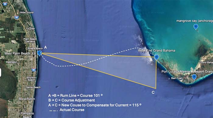
The second figure shows our rum line, the shortest distance between two points (A to B) on a navigational chart. Our actual course (dotted white line) will intentionally be curved to compensate for the Gulfstream’s drift. Before reaching the stream, we will initially head off our rum line by about 8- 15 degrees to the southeast of our waypoint off West End. Once we are out of the strong current, we will be able to head directly to the channel entrance Buoy.

This week, we have pulled the appropriate sails, stocked up on groceries, and refueled. Today, Kim hoisted Scott up the code zero halyard in the bosun’s chair to inspect the rig. He was happy to report that all was in order.

We also found time to explore some local parks and the City of Palm Beach. We toured Jonathan Dickinson State Park, which intersects with the wild and scenic Loxahatchee River. We were astonished to find 13 different natural habitats, including sand pine, scrub pine, flatwoods, mangroves, and river swamps. Hobe Mountain, the tallest point in southern Florida, at only 86 feet above sea level is home to ancient dunes.

With any luck, the weather will cooperate, and we will be able to celebrate our long awaited arrival in the Bahamas by the New Year 2025. This will begin a new adventure in this Lucayan archipelago, which encompasses 5,000 square miles, 700 islands, and 2,400 cays.
Kailoa signing off!


Leave a Reply